
Βαλτέτσι topographic map
Interactive map
Click on the map to display elevation.
Βαλτέτσι
Valtetsi (Greek: Βαλτέτσι) is a village in the municipal unit of Valtetsi, Arcadia, Greece. It is located in the Central Peloponessus in what is called Ορεινή Αρκαδία (Greek: Mountainous Arcadia) at a distance of 12 km west of Tripoli and an altitude of 1,050 m. It is a small plain terrain surrounded by four hills: Chomatovouni, Mylos, Katsikeika and Dovrouleika. It is considered a traditional settlement.
About this map
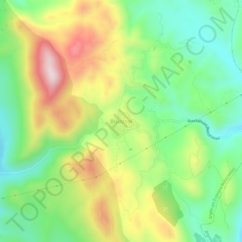
Name: Βαλτέτσι topographic map, elevation, terrain.
Average elevation: 989 m
Minimum elevation: 800 m
Maximum elevation: 1,269 m