Geolocate

Ternopil topographic map

Click on the map to display elevation.

About this map
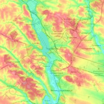
Name: Ternopil topographic map, elevation, terrain.

Location: Ternopil, Ternopil Urban Hromada, Ternopil Raion, Ternopil Oblast, Ukraine (49.50536 25.45860 49.59689 25.66451)

Average elevation: 338 m

Minimum elevation: 293 m

Maximum elevation: 379 m

Other topographic maps

Click on a map to view its topography, its elevation and its terrain.
Hodiv

Ukraine > Ternopil Oblast

Average elevation: 371 m

Gear up for your next adventure:

🕶️Glacier Goggles - Maximum protection for high-altitude snow topography
🗺️Ordnance Survey Maps - Essential paper maps for hiking across the UK national parks
🧢Hiking Hats - Sun and weather protection for outdoor walks
🔭Compact Hiking Binoculars - Lightweight optics for scouting terrain and spotting wildlife
🔦Outdoor Torches - Reliable torches for night navigation

As an Amazon Associate, this site earns from qualifying purchases at no extra cost to you.