Geolocate

Kapar topographic map

Click on the map to display elevation.

About this map
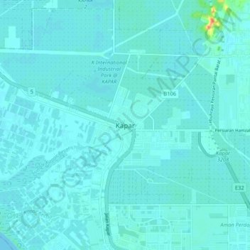
Name: Kapar topographic map, elevation, terrain.

Location: Kapar, Klang City, Klang, Selangor, 42200, Malaysia (3.09775 101.33321 3.17775 101.41321)

Average elevation: 5 m

Minimum elevation: 0 m

Maximum elevation: 52 m

Other topographic maps

Click on a map to view its topography, its elevation and its terrain.
Indah Island

Malaysia > Selangor > Klang City

Average elevation: 3 m

Bukit Kapar

Malaysia > Selangor > Klang City

Average elevation: 24 m

Pulau Ketam

Malaysia > Selangor > Klang City

Average elevation: 1 m

Indah Island

Malaysia > Selangor > Klang City

Average elevation: 3 m

Indah Island

Malaysia > Selangor > Klang City

Average elevation: 3 m

The Boss

Malaysia > Selangor > Klang City

Average elevation: 9 m

Gear up for your next adventure:

🧺Mesh Stuff Sacks - Breathable storage for wet gear or camp organization
🚲Cycling GPS Computers - Track elevation and topographic routes on two wheels
⌚Altimeter Watches - Watches measuring altitude for mountain activities
🧰Survival Kits - Emergency tools for remote environments
🛑Emergency Bivvy Bags - Heat-reflective survival bags for unexpected nights out

As an Amazon Associate, this site earns from qualifying purchases at no extra cost to you.