Geolocate

Springfield topographic map

Click on the map to display elevation.

About this map

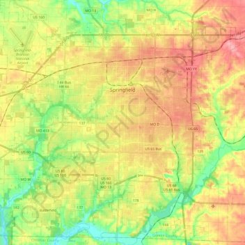
Name: Springfield topographic map, elevation, terrain.

Location: Springfield, Greene County, Missouri, United States (37.08879 -93.41322 37.27698 -93.17850)

Average elevation: 389 m

Minimum elevation: 333 m

Maximum elevation: 448 m

Other topographic maps

Click on a map to view its topography, its elevation and its terrain.

Bois D'Arc

United States > Missouri > Greene County

Average elevation: 371 m

Galloway

United States > Missouri > Greene County > Springfield

Average elevation: 380 m

Mentor

United States > Missouri > Greene County

Average elevation: 402 m

Ebenezer

United States > Missouri > Greene County

Average elevation: 380 m

Ebenezer

United States > Missouri > Greene County

Average elevation: 380 m

Riverpark

United States > Missouri > Greene County > Riverpark

Average elevation: 370 m

Gear up for your next adventure:

🧭Orienteering Compasses - Accurate compasses for map-based navigation
🌦️Portable Weather Meters - Handheld tools for monitoring weather conditions
📻Hand-Crank Emergency Radios - Stay updated on weather warnings in remote areas
🧰First Aid Kits - Essential safety kits for outdoor activities
🩹Hiking First Aid Kits - Compact medical kits tailored for trail injuries and emergencies

As an Amazon Associate, this site earns from qualifying purchases at no extra cost to you.