Geolocate

Paraiso topographic map

Click on the map to display elevation.

About this map

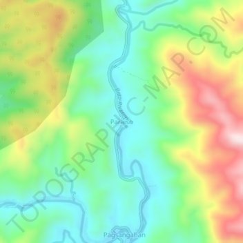
Name: Paraiso topographic map, elevation, terrain.

Location: Paraiso, Catanduanes, Bicol Region, Philippines (13.72342 124.25101 13.76342 124.29101)

Average elevation: 200 m

Minimum elevation: 29 m

Maximum elevation: 496 m

Other topographic maps

Click on a map to view its topography, its elevation and its terrain.

Virac

Philippines > Catanduanes

Average elevation: 95 m

Gear up for your next adventure:

💧Hydration Reservoirs - Convenient water bladders for hands-free drinking on the move
🔋Power Banks - Portable chargers for long outdoor trips
🎒Replacement Sternum Straps - Repair parts for hiking rucksacks
🥤Collapsible Water Bottles - Save space in your rucksack as you consume your water
🥤Hiking Water Bottles - Reusable bottles for hydration on the trail

As an Amazon Associate, this site earns from qualifying purchases at no extra cost to you.