
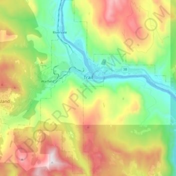
Trail topographic map
Interactive map
Click on the map to display elevation.
About this map
Name: Trail topographic map, elevation, terrain.
Average elevation: 888 m
Minimum elevation: 395 m
Maximum elevation: 1,637 m
Summer climate in Trail is generally hot and dry with moderately cool nights. Temperatures often exceed 35 °C (95 °F) during summer afternoons, average 29 °C (84 °F). Thunderstorms are common during the late-Spring and Summer season, often moving into the valley from the south. The fall months bring dense river fog, especially overnight and in the morning, as a cold air inversion lingers above the relatively warm river surface. Winters are mild to cold with periods of moderate snowfall. Nearby villages such as Warfield, Fruitvale and especially Rossland receive greater amounts of snow due to higher elevation.
Other topographic maps
Click on a map to view its topography, its elevation and its terrain.
Stump Lake
Canada > British Columbia > Regional District of Kootenay Boundary > Area E (Beaverdell/West Boundary)
Stump Lake, Area E (Beaverdell/West Boundary), Regional District of Kootenay Boundary, British Columbia, Canada
Average elevation: 1,321 m
Grand Forks
Canada > British Columbia > Regional District of Kootenay Boundary
Grand Forks, Regional District of Kootenay Boundary, British Columbia, Canada
Average elevation: 586 m
Rossland
Canada > British Columbia > Regional District of Kootenay Boundary
Rossland, Regional District of Kootenay Boundary, British Columbia, V0G 1Y0, Canada
Average elevation: 1,128 m
Regional District of Kootenay Boundary
Canada > British Columbia > Regional District of Kootenay Boundary
Regional District of Kootenay Boundary, British Columbia, Canada
Average elevation: 1,215 m