
Rancagua topographic map
Interactive map
Click on the map to display elevation.
About this map
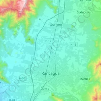
Name: Rancagua topographic map, elevation, terrain.
Location: Rancagua, Provincia de Cachapoal, O'Higgins Region, Chile (-34.21364 -70.94117 -34.02856 -70.67679)
Average elevation: 585 m
Minimum elevation: 406 m
Maximum elevation: 1,839 m
Other topographic maps
Click on a map to view its topography, its elevation and its terrain.
San Isidro
Chile > O'Higgins Region > Provincia de Cachapoal > Graneros
San Isidro, Graneros, Provincia de Cachapoal, O'Higgins Region, 2880000, Chile
Average elevation: 476 m
Rosario
Chile > O'Higgins Region > Provincia de Cachapoal > Rengo
Rosario, Rengo, Provincia de Cachapoal, O'Higgins Region, Chile
Average elevation: 352 m
San Vicente de Tagua Tagua
Chile > O'Higgins Region > Provincia de Cachapoal > San Vicente de Tagua Tagua > San Vicente de Tagua Tagua
San Vicente de Tagua Tagua, Provincia de Cachapoal, O'Higgins Region, 2970000, Chile
Average elevation: 245 m