
Make a donation
Gear up for your next adventure:
As an Amazon Associate, this site earns from qualifying purchases at no extra cost to you.
Fairfield County topographic map
Click on the map to display elevation.
Make a donation
Gear up for your next adventure:
As an Amazon Associate, this site earns from qualifying purchases at no extra cost to you.
Fairfield County
The terrain of the county trends from flat near the coast to hilly and higher near its northern extremity. The highest elevation is 1,290 feet (393 m) above sea level along the New York state line south of Branch Hill in the Town of Sherman; the lowest point is sea level itself.
Make a donation
Gear up for your next adventure:
As an Amazon Associate, this site earns from qualifying purchases at no extra cost to you.
About this map
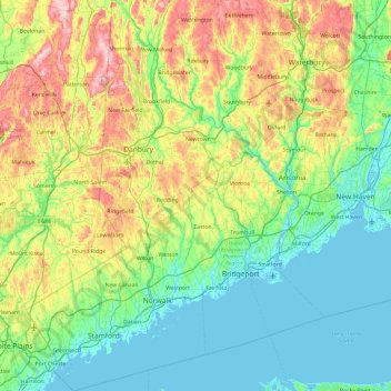
Name: Fairfield County topographic map, elevation, terrain.
Average elevation: 115 m
Minimum elevation: -5 m
Maximum elevation: 408 m
Make a donation
Gear up for your next adventure:
As an Amazon Associate, this site earns from qualifying purchases at no extra cost to you.
Other topographic maps
Click on a map to view its topography, its elevation and its terrain.
Oronoque
United States > Connecticut > Greater Bridgeport Planning Region > Stratford
Average elevation: 37 m
Southport
United States > Connecticut > Greater Bridgeport Planning Region > Fairfield
Average elevation: 11 m
Greenfield Hill
United States > Connecticut > Greater Bridgeport Planning Region > Fairfield
Average elevation: 53 m
Long Hill
United States > Connecticut > Greater Bridgeport Planning Region > Trumbull
Average elevation: 117 m
Make a donation
Gear up for your next adventure:
As an Amazon Associate, this site earns from qualifying purchases at no extra cost to you.
Barn Hill
United States > Connecticut > Greater Bridgeport Planning Region > Monroe
Average elevation: 146 m
Long Hill
United States > Connecticut > Greater Bridgeport Planning Region > Trumbull
Average elevation: 117 m
Powells Hill
United States > Connecticut > Greater Bridgeport Planning Region > Easton
Average elevation: 87 m
Stratfield
United States > Connecticut > Greater Bridgeport Planning Region > Fairfield
Average elevation: 53 m
Make a donation
Gear up for your next adventure:
As an Amazon Associate, this site earns from qualifying purchases at no extra cost to you.
Lordship Beach
United States > Connecticut > Greater Bridgeport Planning Region > Stratford > Lordship
Average elevation: 1 m