
Corozal topographic map
Interactive map
Click on the map to display elevation.
About this map
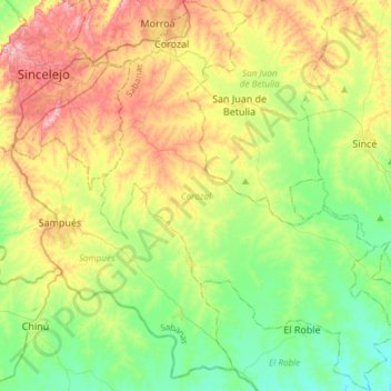
Name: Corozal topographic map, elevation, terrain.
Location: Corozal, Sabanas, Sucre, RAP Caribe, Colombia (9.05731 -75.35886 9.35201 -75.12555)
Average elevation: 128 m
Minimum elevation: 54 m
Maximum elevation: 250 m
Other topographic maps
Click on a map to view its topography, its elevation and its terrain.
San Onofre
San Onofre, Morrosquillo, Sucre, RAP Caribe, 707017, Colombia
Average elevation: 40 m