
Thank you for supporting this site ❤️
Make a donation
Make a donation
Gear up for your next adventure:
As an Amazon Associate, this site earns from qualifying purchases at no extra cost to you.
Vazhikkadavu topographic map
Click on the map to display elevation.
Thank you for supporting this site ❤️
Make a donation
Make a donation
Gear up for your next adventure:
As an Amazon Associate, this site earns from qualifying purchases at no extra cost to you.
About this map
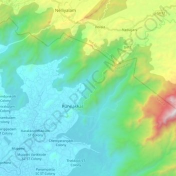
Name: Vazhikkadavu topographic map, elevation, terrain.
Location: Vazhikkadavu, Nilambur, Malappuram, Kerala, 679333, India (11.35239 76.27702 11.46853 76.46195)
Average elevation: 489 m
Minimum elevation: 23 m
Maximum elevation: 2,148 m
Thank you for supporting this site ❤️
Make a donation
Make a donation
Gear up for your next adventure:
As an Amazon Associate, this site earns from qualifying purchases at no extra cost to you.