
Make a donation
Gear up for your next adventure:
As an Amazon Associate, this site earns from qualifying purchases at no extra cost to you.
Hindupur topographic map
Click on the map to display elevation.
Make a donation
Gear up for your next adventure:
As an Amazon Associate, this site earns from qualifying purchases at no extra cost to you.
Hindupur
Even in summers, the city experiences lower temperatures compared to the rest of the state due to its high elevation. Average annual rainfall is 551mm.
Make a donation
Gear up for your next adventure:
As an Amazon Associate, this site earns from qualifying purchases at no extra cost to you.
About this map
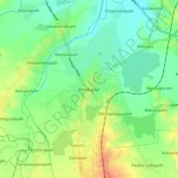
Name: Hindupur topographic map, elevation, terrain.
Location: Hindupur, Sri Sathya Sai, Andhra Pradesh, 515200, India (13.79061 77.45264 13.87061 77.53264)
Average elevation: 623 m
Minimum elevation: 607 m
Maximum elevation: 647 m
Make a donation
Gear up for your next adventure:
As an Amazon Associate, this site earns from qualifying purchases at no extra cost to you.