
Wageningen topographic map
Interactive map
Click on the map to display elevation.
About this map
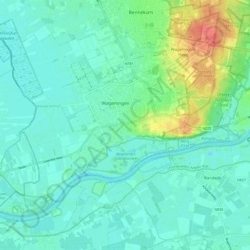
Name: Wageningen topographic map, elevation, terrain.
Location: Wageningen, Gelderland, Netherlands (51.93641 5.60582 52.00071 5.72436)
Average elevation: 14 m
Minimum elevation: 1 m
Maximum elevation: 55 m
Topographic map of the municipality of Wageningen, July 2013 (click to enlarge)
Other topographic maps
Click on a map to view its topography, its elevation and its terrain.
Oostereng
Netherlands > Gelderland > Wageningen > Wageningen-Hoog
Oostereng, Everlaan, Wageningen-Hoog, Wageningen, Gelderland, Netherlands, 6705DK, Netherlands
Average elevation: 29 m