Geolocate

Aston topographic map

Click on the map to display elevation.

About this map
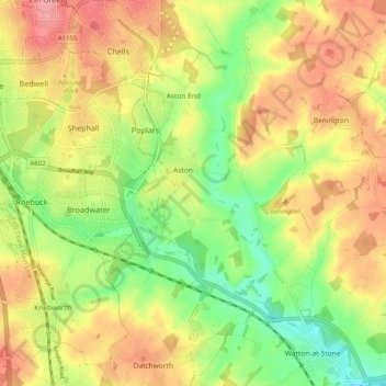
Name: Aston topographic map, elevation, terrain.

Location: Aston, East Hertfordshire, Hertfordshire, England, United Kingdom (51.85320 -0.16118 51.91547 -0.12087)

Average elevation: 99 m

Minimum elevation: 52 m

Maximum elevation: 143 m

Hertfordshire trails, hiking, mountain biking, running and outdoor activities

Other topographic maps

Click on a map to view its topography, its elevation and its terrain.
Gear up for your next adventure:

📻Hand-Crank Emergency Radios - Stay updated on weather warnings in remote areas
🧤Thermal Touchscreen Gloves - Stay warm while operating your GPS or smartphone camera
👟Heavy Duty Boot Laces - Always carry a spare for your hiking footwear
🧷Tenacious Repair Tape - Instant fix for torn tents, jackets, or dry bags
🥼Base Layers - Thermal base layers for temperature regulation

As an Amazon Associate, this site earns from qualifying purchases at no extra cost to you.