Geolocate

Mahbubnagar topographic map

Click on the map to display elevation.

Mahbubnagar

Mahbubnagar is located at 16°44′N 77°59′E / 16.73°N 77.98°E / 16.73; 77.98. It has an average elevation of 498 metres (1633 feet). The city of Mahbubnagar is located at a distance of 98 km from Hyderabad, 130 km from Kurnool and 151 km from Gulbarga.

Wikipedia (CC-BY-SA 3.0)

About this map

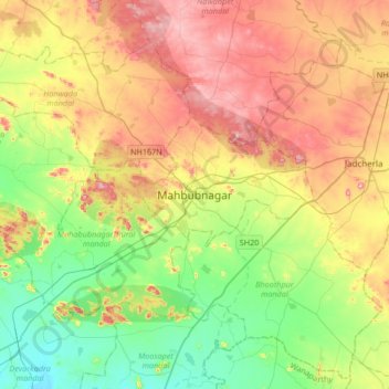
Name: Mahbubnagar topographic map, elevation, terrain.

Location: Mahbubnagar, Mahabubnagar_Urban mandal, Mahabubnagar, Telangana, 509001, India (16.58345 77.83232 16.90345 78.15232)

Average elevation: 509 m

Minimum elevation: 373 m

Maximum elevation: 700 m

Gear up for your next adventure:

🔦Head Torches - Hands-free lighting for hiking and camping
🧢Thermal Beanie Hats - Prevent heat loss from the head in windy summit conditions
🧴Tick Removal Tools - Small, essential health tool for UK woodland and moorland
🧣Neck Gaiters - Protects against wind and sun on exposed ridges and peaks
🎒Hiking Daypacks - Compact backpacks ideal for short hikes and excursions

As an Amazon Associate, this site earns from qualifying purchases at no extra cost to you.