Geolocate

Leavenworth topographic map

Click on the map to display elevation.

Leavenworth

Leavenworth is located at 39°18′40″N 94°55′21″W / 39.31111°N 94.92250°W / 39.31111; -94.92250 (39.3111112, −94.9224637) at an elevation of 840 feet (256 m).[5] Located in northeastern Kansas at the junction of U.S. Route 73 and Kansas Highway 92 (K-92), Leavenworth is 25 mi (40 km) northwest of downtown Kansas City, 145 mi (233 km) south-southeast of Omaha, and 165 mi (266 km) northeast of Wichita.[18][19]

About this map

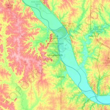
Name: Leavenworth topographic map, elevation, terrain.

Location: Leavenworth, Leavenworth County, Kansas, 66048, United States (39.15133 -95.08276 39.47133 -94.76276)

Average elevation: 277 m

Minimum elevation: 223 m

Maximum elevation: 347 m

Gear up for your next adventure:

🔥Emergency Fire Starters - Reliable ignition tools for survival situations in damp conditions
🖼️Topographic Map Art - Decorative 3D-effect posters of famous UK peaks and regions
🥼Base Layers - Thermal base layers for temperature regulation
🐕Hiking Dog Harnesses - Rugged harnesses for taking your companion on mountain trails
🔦Waterproof LED Headlamps - Hands-free lighting for evening treks and emergency navigation

As an Amazon Associate, this site earns from qualifying purchases at no extra cost to you.