
Make a donation
Gear up for your next adventure:
As an Amazon Associate, this site earns from qualifying purchases at no extra cost to you.
Cahul topographic map
Click on the map to display elevation.
Make a donation
Gear up for your next adventure:
As an Amazon Associate, this site earns from qualifying purchases at no extra cost to you.
About this map
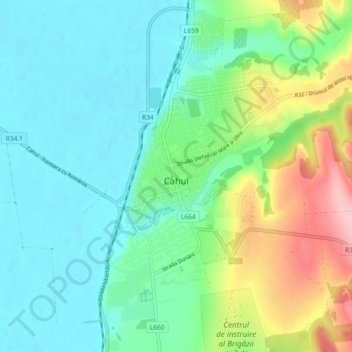
Name: Cahul topographic map, elevation, terrain.
Location: Cahul, Cahul District, Moldova (45.87338 28.17360 45.93703 28.22314)
Average elevation: 48 m
Minimum elevation: 2 m
Maximum elevation: 171 m
Make a donation
Gear up for your next adventure:
As an Amazon Associate, this site earns from qualifying purchases at no extra cost to you.
Other topographic maps
Click on a map to view its topography, its elevation and its terrain.
Make a donation
Gear up for your next adventure:
As an Amazon Associate, this site earns from qualifying purchases at no extra cost to you.
Criuleni District
Criuleni District is located in the central part of Moldova. Does the neighborhood: in the north Orhei District, Dubăsari District in the east, south Anenii Noi District, in western Municipality of Chișinău, and Strășeni District. District is located within the eastern extremity of Central Moldavian…
Average elevation: 122 m
Make a donation
Gear up for your next adventure:
As an Amazon Associate, this site earns from qualifying purchases at no extra cost to you.
Make a donation
Gear up for your next adventure:
As an Amazon Associate, this site earns from qualifying purchases at no extra cost to you.
Make a donation
Gear up for your next adventure:
As an Amazon Associate, this site earns from qualifying purchases at no extra cost to you.
Drochia
Drochia (Romanian pronunciation: ) is a city in the northern part of Moldova. It is the administrative center of the eponymous district. The city is located 174.4 km (108.4 mi) north of the national capital, Chişinău, and 67 km (42 mi) north-east of the Romanian city of Iaşi. The average elevation of…
Average elevation: 164 m
Make a donation
Gear up for your next adventure:
As an Amazon Associate, this site earns from qualifying purchases at no extra cost to you.