
Monroe topographic map
Interactive map
Click on the map to display elevation.
About this map
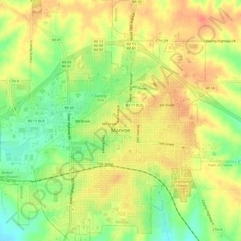
Name: Monroe topographic map, elevation, terrain.
Location: Monroe, Green County, Wisconsin, 53566, United States (42.58199 -89.67170 42.62514 -89.61830)
Average elevation: 324 m
Minimum elevation: 292 m
Maximum elevation: 348 m
Other topographic maps
Click on a map to view its topography, its elevation and its terrain.
Dayton
United States > Wisconsin > Green County
Dayton, Town of Exeter, Green County, Wisconsin, 53508, United States
Average elevation: 265 m
Monroe
United States > Wisconsin > Green County
Monroe, Green County, Wisconsin, United States
Average elevation: 312 m
New Glarus
United States > Wisconsin > Green County > New Glarus
New Glarus, Green County, Wisconsin, 53574, United States
Average elevation: 285 m