Geolocate

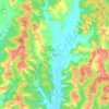
Tonco topographic map

Click on the map to display elevation.

About this map

Name: Tonco topographic map, elevation, terrain.

Location: Tonco, Asti, Piedmont, 14039, Italy (45.00098 8.15843 45.04368 8.21900)

Average elevation: 187 m

Minimum elevation: 143 m

Maximum elevation: 275 m

Other topographic maps

Click on a map to view its topography, its elevation and its terrain.

Gatti

Italy > Piedmont > Asti > Rocchetta Tanaro

Average elevation: 165 m

Sant'Andrea

Italy > Piedmont > Asti > Cerreto d'Asti

Average elevation: 270 m

Zolfo

Italy > Piedmont > Asti > Montafia

Average elevation: 226 m

Gear up for your next adventure:

🕶️Glacier Goggles - Maximum protection for high-altitude snow topography
🧦Hiking Socks - Breathable socks designed to prevent blisters on long walks
👕Technical Hiking Tees - Moisture-management for high-exertion climbs
🗺️Ordnance Survey Maps - Essential paper maps for hiking across the UK national parks
🧭Orienteering Compasses - Accurate compasses for map-based navigation

As an Amazon Associate, this site earns from qualifying purchases at no extra cost to you.