
Sorel-Tracy topographic map
Interactive map
Click on the map to display elevation.
About this map
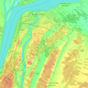
Name: Sorel-Tracy topographic map, elevation, terrain.
Location: Sorel-Tracy, Pierre-De Saurel, Montérégie, Quebec, Canada (45.95517 -73.18115 46.05155 -73.01084)
Average elevation: 16 m
Minimum elevation: 0 m
Maximum elevation: 33 m
Other topographic maps
Click on a map to view its topography, its elevation and its terrain.
Saint-Roch-de-Richelieu
Canada > Quebec > Pierre-De Saurel
Saint-Roch-de-Richelieu, Pierre-De Saurel, Montérégie, Quebec, Canada
Average elevation: 18 m