Geolocate

Κρηνίδες topographic map

Interactive map

Click on the map to display elevation.

About this map

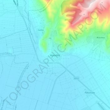
Name: Κρηνίδες topographic map, elevation, terrain.

Location: Κρηνίδες, Kavala Municipality, Kavala Regional Unit, Eastern Macedonia and Thrace, Macedonia and Thrace, 640 03, Greece (40.97207 24.25519 41.05207 24.33519)

Average elevation: 142 m

Minimum elevation: 40 m

Maximum elevation: 797 m

Other topographic maps

Click on a map to view its topography, its elevation and its terrain.

Kavala

Greece > Macedonia and Thrace > Kavala Regional Unit

On July 16, 2022, Meridian Flight 3032 crashed near the village. The Ukrainian-registered Antonov An-12BK was carrying 11.5 tons of ammunition from Nis to Dhaka when the plane began to lose altitude over the Aegean and turned around, but went down 35 kilometers west of Kavala Airport. All 8 crew members were…

Average elevation: 173 m