
Büyükçekmece topographic map
Interactive map
Click on the map to display elevation.
About this map
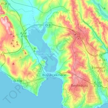
Name: Büyükçekmece topographic map, elevation, terrain.
Location: Büyükçekmece, Istanbul, Marmara Region, Turkey (40.98450 28.39099 41.12963 28.63402)
Average elevation: 69 m
Minimum elevation: -2 m
Maximum elevation: 229 m
Other topographic maps
Click on a map to view its topography, its elevation and its terrain.
Istanbul
Istanbul, located in northwestern Turkey, is a city that is uniquely situated across two continents, Europe and Asia, divided by the Bosphorus Strait. The city’s topography is characterized by a complex blend of hills, valleys, and coastal plains, which create a varied and scenic landscape. The European side…
Average elevation: 57 m