Geolocate

Pargas topographic map

Click on the map to display elevation.

About this map

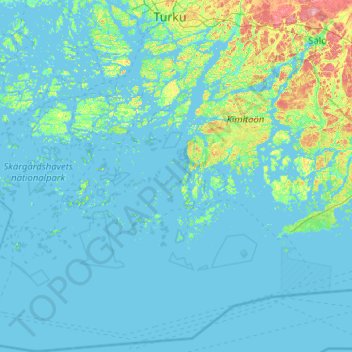
Name: Pargas topographic map, elevation, terrain.

Location: Pargas, Aboland, Southwest Finland, Mainland Finland, Finland (59.47265 20.81315 60.49867 22.54300)

Average elevation: 9 m

Minimum elevation: -5 m

Maximum elevation: 118 m

Other topographic maps

Click on a map to view its topography, its elevation and its terrain.

Alastaro

Finland > Southwest Finland

Average elevation: 80 m

Riihikoski

Finland > Southwest Finland

Average elevation: 68 m

Virttaa

Finland > Southwest Finland > Loimaa

Average elevation: 86 m

Kalanti

Finland > Southwest Finland > Uusikaupunki

Average elevation: 16 m

Ojankulma

Finland > Southwest Finland > Nousiainen

Average elevation: 44 m

Kaivonpyöli

Finland > Southwest Finland > Salo > Muurla

Average elevation: 45 m

Palstakulma

Finland > Southwest Finland > Salo > Halikko

Average elevation: 21 m

31.8

Finland > Southwest Finland > Kaarina

Average elevation: 11 m

Kallela

Finland > Southwest Finland > Lemu

Average elevation: 17 m

Pyhe

Finland > Southwest Finland > Mynämäki

Average elevation: 8 m

Gear up for your next adventure:

🧭GPS Trackers - Tracking devices for safety and navigation
🧺Microfibre Travel Towels - Fast-drying and compact towels for wild swimming and camping
🗺️Ordnance Survey Maps - Essential paper maps for hiking across the UK national parks
🕶️Polarized Sunglasses - Reduces glare from snow and water when reading terrain
📷Camera Straps - Secure straps for carrying cameras while walking

As an Amazon Associate, this site earns from qualifying purchases at no extra cost to you.