
Town of Shelburne topographic map
Interactive map
Click on the map to display elevation.
About this map
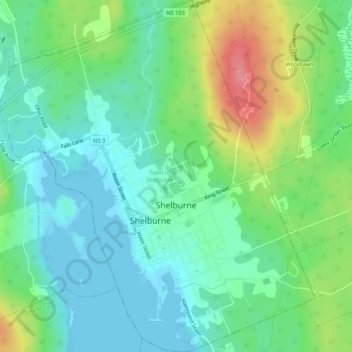
Name: Town of Shelburne topographic map, elevation, terrain.
Location: Town of Shelburne, Shelburne County, Nova Scotia, Canada (43.74952 -65.34439 43.78805 -65.29645)
Average elevation: 28 m
Minimum elevation: -1 m
Maximum elevation: 91 m
Other topographic maps
Click on a map to view its topography, its elevation and its terrain.
Town of Clark's Harbour
Canada > Nova Scotia > Shelburne County
Town of Clark's Harbour, Shelburne County, Nova Scotia, Canada
Average elevation: 2 m
Stoney Island
Canada > Nova Scotia > Shelburne County
Stoney Island, Municipality of the District of Barrington, Shelburne County, Nova Scotia, B0W 1P0, Canada
Average elevation: 3 m
Canada Hill
Canada > Nova Scotia > Shelburne County > Canada Hill
Canada Hill, Municipality of the District of Shelburne, Shelburne County, Nova Scotia, B0T 1L0, Canada
Average elevation: 34 m
Churchover
Canada > Nova Scotia > Shelburne County
Churchover, Municipality of the District of Shelburne, Shelburne County, Nova Scotia, B0T 1W0, Canada
Average elevation: 27 m
Ingomar
Canada > Nova Scotia > Shelburne County
Ingomar, Municipality of the District of Shelburne, Shelburne County, Nova Scotia, B0T 1W0, Canada
Average elevation: 5 m
Shelburne
Canada > Nova Scotia > Shelburne County > Shelburne
Shelburne, Town of Shelburne, Shelburne County, Nova Scotia, Canada
Average elevation: 28 m