
Thank you for supporting this site ❤️
Make a donation
Make a donation
Gear up for your next adventure:
As an Amazon Associate, this site earns from qualifying purchases at no extra cost to you.
Thessaly - Central Greece topographic map
Click on the map to display elevation.
Gear up for your next adventure:
As an Amazon Associate, this site earns from qualifying purchases at no extra cost to you.
About this map
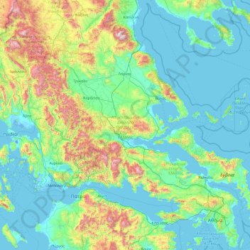
Name: Thessaly - Central Greece topographic map, elevation, terrain.
Location: Thessaly - Central Greece, Greece (37.89138 21.12042 40.19666 24.76990)
Average elevation: 367 m
Minimum elevation: -7 m
Maximum elevation: 2,747 m
Thank you for supporting this site ❤️
Make a donation
Make a donation
Gear up for your next adventure:
As an Amazon Associate, this site earns from qualifying purchases at no extra cost to you.