Geolocate

Grantville topographic map

Click on the map to display elevation.

About this map
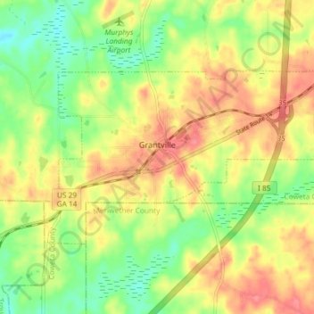
Name: Grantville topographic map, elevation, terrain.

Location: Grantville, Coweta County, Georgia, 30220, United States (33.21570 -84.86217 33.24970 -84.78864)

Average elevation: 245 m

Minimum elevation: 209 m

Maximum elevation: 280 m

Other topographic maps

Click on a map to view its topography, its elevation and its terrain.
Newnan Pines

United States > Georgia > Coweta County

Average elevation: 278 m

Sargent

United States > Georgia > Coweta County

Average elevation: 247 m

Welcome

United States > Georgia > Coweta County > Newnan

Average elevation: 257 m

Arnco Mills

United States > Georgia > Coweta County

Average elevation: 256 m

Lambert Field

United States > Georgia > Coweta County > Newnan

Average elevation: 285 m

Gear up for your next adventure:

⛺Camping Shelters - Emergency and lightweight shelters for outdoor use
🥾Hiking Boots - Waterproof and durable boots for long-distance hiking in the UK
🦶Anti-Blister Balms - Protect your feet before long topographic expeditions
🦯Walking Poles - Supportive poles for long-distance walking
🛌Insulated Sleeping Mats - Crucial thermal protection when sleeping on cold, uneven ground

As an Amazon Associate, this site earns from qualifying purchases at no extra cost to you.