Geolocate

Waskemeer topographic map

Click on the map to display elevation.

About this map
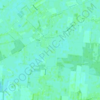
Name: Waskemeer topographic map, elevation, terrain.

Location: Waskemeer, Ooststellingwerf, Frisia, Netherlands (53.03583 6.25111 53.06941 6.30541)

Average elevation: 7 m

Minimum elevation: 3 m

Maximum elevation: 10 m

Other topographic maps

Click on a map to view its topography, its elevation and its terrain.
Leeuwarden

Netherlands > Frisia > Leeuwarden

Average elevation: 0 m

Vierhuizen

Netherlands > Frisia > Allingawier

Average elevation: -2 m

Oost-Vlieland

Netherlands > Frisia

Average elevation: 2 m

Kooiplaats

Netherlands > Frisia > Buren

Average elevation: 1 m

Loënga

Netherlands > Frisia > Loënga

Average elevation: 0 m

Gear up for your next adventure:

👖Packable Overtrousers - Quick-deploy rain protection for legs in sudden storms
🧥Breathable Waterproof Jackets - Essential rain protection for the unpredictable British climate
🧣Neck Gaiters - Versatile protection against wind and cold
📻Hand-Crank Emergency Radios - Stay updated on weather warnings in remote areas
📐Altimeters & Barometers - Tools for measuring altitude and air pressure

As an Amazon Associate, this site earns from qualifying purchases at no extra cost to you.