
Make a donation
Gear up for your next adventure:
As an Amazon Associate, this site earns from qualifying purchases at no extra cost to you.
Mont-Dore topographic map
Click on the map to display elevation.
Make a donation
Gear up for your next adventure:
As an Amazon Associate, this site earns from qualifying purchases at no extra cost to you.
Mont-Dore
Sodium bicarbonate, iron and arsenic are the principal ingredients of the springs, which are used both for drinking and bathing. Hot baths are characteristic of the treatment; they are believed to be efficacious for tuberculosis, bronchitis, asthma, and nervous and rheumatic paralysis. Due to the elevation and exposure of the valley, the climate of Mont-Dore is relatively severe, and the season only lasts from 15 June to 15 September. The bath-house was rebuilt in 1891–1894.
Make a donation
Gear up for your next adventure:
As an Amazon Associate, this site earns from qualifying purchases at no extra cost to you.
About this map
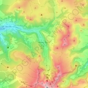
Name: Mont-Dore topographic map, elevation, terrain.
Average elevation: 1,300 m
Minimum elevation: 860 m
Maximum elevation: 1,872 m
Make a donation
Gear up for your next adventure:
As an Amazon Associate, this site earns from qualifying purchases at no extra cost to you.
Other topographic maps
Click on a map to view its topography, its elevation and its terrain.
Make a donation
Gear up for your next adventure:
As an Amazon Associate, this site earns from qualifying purchases at no extra cost to you.
La Graissière
France > Auvergne-Rhône-Alpes > Puy-de-Dôme > Saint-Genès-Champanelle
Average elevation: 984 m
Make a donation
Gear up for your next adventure:
As an Amazon Associate, this site earns from qualifying purchases at no extra cost to you.
Soulace
France > Auvergne-Rhône-Alpes > Puy-de-Dôme > Marsac-en-Livradois > Flaittes
Average elevation: 621 m
Les Gicons
France > Auvergne-Rhône-Alpes > Puy-de-Dôme > Montaigut-en-Combraille
Average elevation: 608 m
Beaune-le-Chaud
France > Auvergne-Rhône-Alpes > Puy-de-Dôme > Saint-Genès-Champanelle
Average elevation: 941 m
La Live
France > Auvergne-Rhône-Alpes > Puy-de-Dôme > Glaine-Montaigut > Glaine
Average elevation: 363 m
Make a donation
Gear up for your next adventure:
As an Amazon Associate, this site earns from qualifying purchases at no extra cost to you.
Make a donation
Gear up for your next adventure:
As an Amazon Associate, this site earns from qualifying purchases at no extra cost to you.
Make a donation
Gear up for your next adventure:
As an Amazon Associate, this site earns from qualifying purchases at no extra cost to you.
La Cottas
France > Auvergne-Rhône-Alpes > Puy-de-Dôme > Champétières > Chatelet
Average elevation: 779 m
Andan
France > Auvergne-Rhône-Alpes > Puy-de-Dôme > Saint-Jacques-d'Ambur > Andan
Average elevation: 624 m
Les Chaux
France > Auvergne-Rhône-Alpes > Puy-de-Dôme > Saint-Amant-Roche-Savine > Les Chaux
Average elevation: 901 m
Make a donation
Gear up for your next adventure:
As an Amazon Associate, this site earns from qualifying purchases at no extra cost to you.
Mareuge
France > Auvergne-Rhône-Alpes > Puy-de-Dôme > Le Vernet-Sainte-Marguerite
Average elevation: 1,062 m