
Lower Uele topographic map
Interactive map
Click on the map to display elevation.
About this map
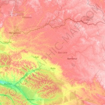
Name: Lower Uele topographic map, elevation, terrain.
Location: Lower Uele, Democratic Republic of the Congo (1.93821 22.43340 5.39200 27.70210)
Average elevation: 552 m
Minimum elevation: 343 m
Maximum elevation: 837 m
Other topographic maps
Click on a map to view its topography, its elevation and its terrain.
Bambili
Democratic Republic of the Congo > Lower Uele
Bambili, Lower Uele, Democratic Republic of the Congo
Average elevation: 606 m
Yoko
Democratic Republic of the Congo > Lower Uele
Yoko, Aketi, Lower Uele, Democratic Republic of the Congo
Average elevation: 461 m