
Brits topographic map
Click on the map to display elevation.
About this map
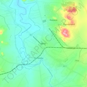
Name: Brits topographic map, elevation, terrain.
Average elevation: 1,120 m
Minimum elevation: 1,074 m
Maximum elevation: 1,263 m
Other topographic maps
Click on a map to view its topography, its elevation and its terrain.
Hartbeespoort Dam
South Africa > North West > Bojanala Platinum District Municipality > Madibeng Local Municipality > Kosmos
Average elevation: 1,254 m
Rooikoppies Dam
South Africa > North West > Bojanala Platinum District Municipality > Madibeng Local Municipality
Average elevation: 1,047 m
Pienaars River
South Africa > North West > Bojanala Platinum District Municipality > Madibeng Local Municipality
Average elevation: 1,032 m
Ukutula Lodge & Lion Park
South Africa > North West > Bojanala Platinum District Municipality > Madibeng Local Municipality
Average elevation: 1,085 m
Rooikoppies Dam
South Africa > North West > Bojanala Platinum District Municipality > Madibeng Local Municipality
Average elevation: 1,047 m
Madibeng Ward 14
South Africa > North West > Bojanala Platinum District Municipality > Madibeng Local Municipality
Average elevation: 1,067 m