
Valencia topographic map
Interactive map
Click on the map to display elevation.
About this map
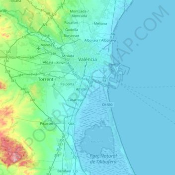
Name: Valencia topographic map, elevation, terrain.
Average elevation: 37 m
Minimum elevation: -6 m
Maximum elevation: 346 m
The maximum of precipitation occurs in the Autumn, coinciding with the time of the year when cold drop (gota fría) episodes of heavy rainfall—associated to cut-off low pressure systems at high altitude— are common along the Western mediterranean coast. The year-on-year variability in precipitation may be, however, considerable.
Other topographic maps
Click on a map to view its topography, its elevation and its terrain.
Platja del Cabanyal - Les Arenes
Spain > Valencian Community > Comarca de València > Valencia
Platja del Cabanyal - Les Arenes, Poblats Marítims, Valencia, Comarca de València, Valencia, Valencian Community, Spain
Average elevation: 2 m