
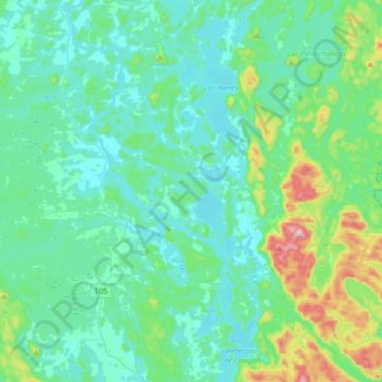
Lac-Sainte-Marie topographic map
Interactive map
Click on the map to display elevation.
About this map
Name: Lac-Sainte-Marie topographic map, elevation, terrain.
Average elevation: 206 m
Minimum elevation: 136 m
Maximum elevation: 546 m
Other topographic maps
Click on a map to view its topography, its elevation and its terrain.
Low
Canada > Quebec > La Vallée-de-la-Gatineau
Low, La Vallée-de-la-Gatineau, Outaouais, Quebec, J0X 2C0, Canada
Average elevation: 220 m
Messines
Canada > Quebec > La Vallée-de-la-Gatineau
Messines, La Vallée-de-la-Gatineau, Outaouais, Quebec, J0X 2J0, Canada
Average elevation: 193 m
Blue Sea
Canada > Quebec > La Vallée-de-la-Gatineau > Blue Sea
Blue Sea, La Vallée-de-la-Gatineau, Outaouais, Quebec, J0X 1C0, Canada
Average elevation: 203 m