Geolocate

K'gari topographic map

Click on the map to display elevation.

About this map

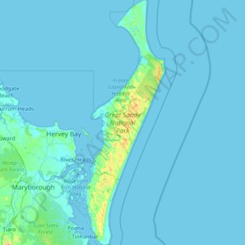
Name: K'gari topographic map, elevation, terrain.

Location: K'gari, Bundaberg Region, Queensland, Australia (-25.79749 152.94269 -24.69714 153.36028)

Average elevation: 11 m

Minimum elevation: -2 m

Maximum elevation: 383 m

Other topographic maps

Click on a map to view its topography, its elevation and its terrain.

Bundaberg

Australia > Queensland > Bundaberg Region

Average elevation: 18 m

Bundaberg

Australia > Queensland > Bundaberg Region

Average elevation: 18 m

Gin Gin

Australia > Queensland > Bundaberg Region > Gin Gin

Average elevation: 73 m

Bundaberg

Australia > Queensland > Bundaberg Region

Average elevation: 18 m

Burrum River

Australia > Queensland > Bundaberg Region > Buxton

Average elevation: 20 m

Isis River

Australia > Queensland > Bundaberg Region > Buxton

Average elevation: 12 m

Gear up for your next adventure:

🧥Breathable Waterproof Jackets - Essential rain protection for the unpredictable British climate
🔦Keychain LED Torches - Emergency backup light for finding gear in your pack
🧘Folding Sit Mats - Dry and warm seat for map-reading breaks on damp ground
🧼Biodegradable Soap - Leave-no-trace hygiene for multi-day mountain treks
🧺Mesh Stuff Sacks - Breathable storage for wet gear or camp organization

As an Amazon Associate, this site earns from qualifying purchases at no extra cost to you.