
Nefas Silk topographic map
Interactive map
Click on the map to display elevation.
About this map
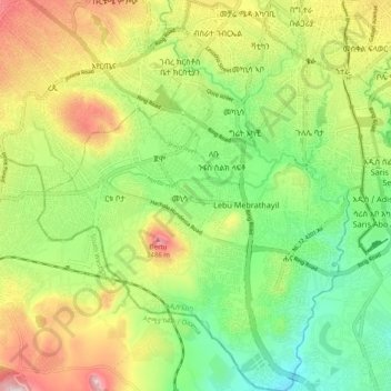
Name: Nefas Silk topographic map, elevation, terrain.
Location: Nefas Silk, Addis Ababa, 0006, Ethiopia (8.90089 38.68009 9.00005 38.77758)
Average elevation: 2,269 m
Minimum elevation: 2,080 m
Maximum elevation: 2,547 m
Other topographic maps
Click on a map to view its topography, its elevation and its terrain.
Addis Ababa
Ethiopia > Addis Ababa > Arada
Moreover, the city held strong social organizations pattern prior Italian invasion. According to Richard Pankhurst (1968), the city accelerated population growth due to factors of provisional governors and their troops, the 1892 famine, eventually the Battle of Adwa. Another include the 1907 land act,…
Average elevation: 2,517 m