
Make a donation
Gear up for your next adventure:
As an Amazon Associate, this site earns from qualifying purchases at no extra cost to you.
Tanur topographic map
Click on the map to display elevation.
Make a donation
Gear up for your next adventure:
As an Amazon Associate, this site earns from qualifying purchases at no extra cost to you.
Tanur
Tanur is located at 10°58′N 75°52′E / 10.97°N 75.87°E / 10.97; 75.87. It has an average elevation of 1 m (3.3 ft).
Make a donation
Gear up for your next adventure:
As an Amazon Associate, this site earns from qualifying purchases at no extra cost to you.
About this map
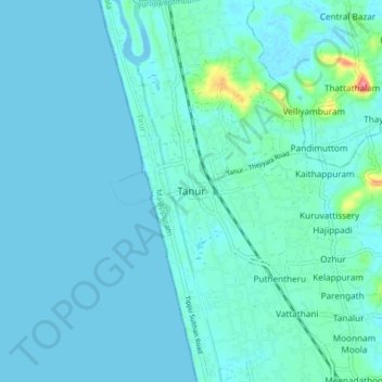
Name: Tanur topographic map, elevation, terrain.
Location: Tanur, Tirur, Malappuram, Kerala, 676302, India (10.93834 75.83636 11.01834 75.91636)
Average elevation: 8 m
Minimum elevation: -2 m
Maximum elevation: 72 m
Make a donation
Gear up for your next adventure:
As an Amazon Associate, this site earns from qualifying purchases at no extra cost to you.
Other topographic maps
Click on a map to view its topography, its elevation and its terrain.
Make a donation
Gear up for your next adventure:
As an Amazon Associate, this site earns from qualifying purchases at no extra cost to you.