
Make a donation
Gear up for your next adventure:
As an Amazon Associate, this site earns from qualifying purchases at no extra cost to you.
Jerimoth Hill topographic map
Click on the map to display elevation.
Make a donation
Gear up for your next adventure:
As an Amazon Associate, this site earns from qualifying purchases at no extra cost to you.
Jerimoth Hill
The hill is located on Route 101 in Foster, a half mile from the Connecticut line. To ascend the summit, for which there is a sign, there is a 0.3-mile (480 m) long trail that has a mere 10-foot (3.0 m) elevation gain. The hill is 812 feet (247 m) high and is located 15 miles (24 km) west of Providence, Rhode Island, and 35 miles (56 km) east of Willimantic, Connecticut.
Make a donation
Gear up for your next adventure:
As an Amazon Associate, this site earns from qualifying purchases at no extra cost to you.
About this map
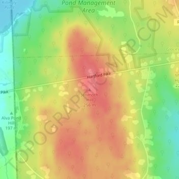
Name: Jerimoth Hill topographic map, elevation, terrain.
Average elevation: 216 m
Minimum elevation: 176 m
Maximum elevation: 247 m
Make a donation
Gear up for your next adventure:
As an Amazon Associate, this site earns from qualifying purchases at no extra cost to you.