
Springs topographic map
Click on the map to display elevation.
About this map
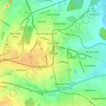
Name: Springs topographic map, elevation, terrain.
Average elevation: 1,606 m
Minimum elevation: 1,569 m
Maximum elevation: 1,674 m
Other topographic maps
Click on a map to view its topography, its elevation and its terrain.
Bill Stewart Nature Reserve
South Africa > Gauteng > City of Ekurhuleni Metropolitan Municipality
Average elevation: 1,695 m
Blaaupan Dam
South Africa > Gauteng > City of Ekurhuleni Metropolitan Municipality
Average elevation: 1,656 m
Daveyton
South Africa > Gauteng > City of Ekurhuleni Metropolitan Municipality
Average elevation: 1,613 m
Blesbokspruit
South Africa > Gauteng > City of Ekurhuleni Metropolitan Municipality
Average elevation: 1,611 m
Korsman Bird Sanctuary
South Africa > Gauteng > City of Ekurhuleni Metropolitan Municipality > Benoni
Average elevation: 1,644 m
Daveyton
South Africa > Gauteng > City of Ekurhuleni Metropolitan Municipality
Average elevation: 1,613 m
Etwatwa
South Africa > Gauteng > City of Ekurhuleni Metropolitan Municipality
Average elevation: 1,611 m
Daveyton
South Africa > Gauteng > City of Ekurhuleni Metropolitan Municipality
Average elevation: 1,613 m