
Meßstetten topographic map
Interactive map
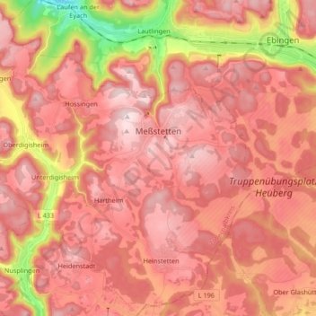
Click on the map to display elevation.
About this map
Name: Meßstetten topographic map, elevation, terrain.
Average elevation: 862 m
Minimum elevation: 596 m
Maximum elevation: 989 m
Meßstetten (German: [mɛsˈʃtɛtn] ) is a town in the Zollernalbkreis district, in Baden-Württemberg, Germany, which is situated in the Swabian Jura, 24 km southeast of Balingen. At an altitude of 907 m (2,976 ft), Meßstetten is the highest city (of more than 10,000 inhabitants) in Germany. It is close to the Heuberg Training Area with the Lager Heuberg. Within the Heuberg Training Area there is the legendary Dreibannmarke, also called the "Bahn", a 17th-century border, which today marks the border between three different municipalities, formerly in the three states of Württemberg, Baden, and Hohenzollern. The meadow at the Dreibannmarke served as a stopping place for traveling merchants, wagons and craftsmen. With care it is possible to identify traces of the border. After the inauguration of the firing ranges, a meadow in Meßstetten was allocated as a camping site at the edge of the restricted area. Until 1835 merchandise was smuggled over the customs borders guarded by local hunters. Coffee smuggler Haux had was killed on 21 July 1831 in Pfaffental. Between 1934 and 1942, many men were sterilized because of "hereditary diseases". Under the program known as Aktion T4, the Nazis murdered mentally handicapped and mentally ill patients. These men and women were deported to the Grafeneck Killing Facility, where they were killed as "life unworthy of life". After the closure of Grafeneck in December 1940, a further deportation to the Hadamar Killing Facility occurred on 1941. After war a new city called Ostlandsiedlung was built.
Other topographic maps
Click on a map to view its topography, its elevation and its terrain.
Zollerberg
Germany > Baden-Württemberg > Zollernalbkreis > Bisingen > Zimmern
Zollerberg, Zimmern, Bisingen, Gemeindeverwaltungsverband Bisingen, Zollernalbkreis, Baden-Württemberg, 72379, Germany
Average elevation: 609 m
Albstadt
Germany > Baden-Württemberg > Zollernalbkreis
Albstadt, Gemeindeverwaltungsverband Albstadt, Zollernalbkreis, Baden-Württemberg, Germany
Average elevation: 820 m