Geolocate

Inticho topographic map

Click on the map to display elevation.

About this map

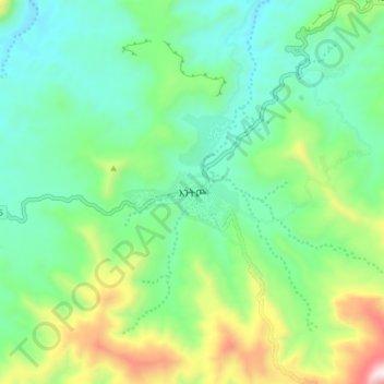
Name: Inticho topographic map, elevation, terrain.

Location: Inticho, Central Tigray, Tigray, Ethiopia (14.23812 39.11065 14.31812 39.19065)

Average elevation: 2,103 m

Minimum elevation: 1,848 m

Maximum elevation: 2,748 m

Other topographic maps

Click on a map to view its topography, its elevation and its terrain.

Eastern Tigray

Ethiopia > Tigray

Average elevation: 1,819 m

Gear up for your next adventure:

🧼Biodegradable Soap - Leave-no-trace hygiene for multi-day mountain treks
🧭Professional Hiking Compasses - High-precision liquid-filled compasses for map reading and orientation
🧥Packable Down Jackets - Lightweight warmth that compresses small in your bag
🎒Hiking Backpacks - Comfortable backpacks for day hikes and multi-day treks
🥾Walking Shoes - Lightweight walking shoes for countryside and coastal paths

As an Amazon Associate, this site earns from qualifying purchases at no extra cost to you.