
Make a donation
Gear up for your next adventure:
As an Amazon Associate, this site earns from qualifying purchases at no extra cost to you.
Nizhny Novgorod topographic map
Click on the map to display elevation.
Make a donation
Gear up for your next adventure:
As an Amazon Associate, this site earns from qualifying purchases at no extra cost to you.
Nizhny Novgorod
Originally, the name was just Novgorod ('Newtown'), but to distinguish it from the other, older and well-known Novgorod (Veliky Novgorod) to the west, the city was commonly called Novgorod of the Lower Lands, or Lower Newtown. The city and surrounding land is called lower (nizhniy; нижний), even though it is actually higher in altitude than Veliky Novgorod, because it is situated downstream of other Russian cities such as Moscow, Vladimir and Murom.
Make a donation
Gear up for your next adventure:
As an Amazon Associate, this site earns from qualifying purchases at no extra cost to you.
About this map
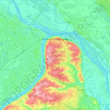
Name: Nizhny Novgorod topographic map, elevation, terrain.
Average elevation: 92 m
Minimum elevation: 59 m
Maximum elevation: 209 m
Make a donation
Gear up for your next adventure:
As an Amazon Associate, this site earns from qualifying purchases at no extra cost to you.
Other topographic maps
Click on a map to view its topography, its elevation and its terrain.
Nizhny Novgorod
Russia > Nizhny Novgorod Oblast > Nizhny Novgorod > Nizhny Novgorod
Average elevation: 87 m