
Make a donation
Gear up for your next adventure:
As an Amazon Associate, this site earns from qualifying purchases at no extra cost to you.
Municipio Alberto Adriani topographic map
Click on the map to display elevation.
Make a donation
Gear up for your next adventure:
As an Amazon Associate, this site earns from qualifying purchases at no extra cost to you.
About this map
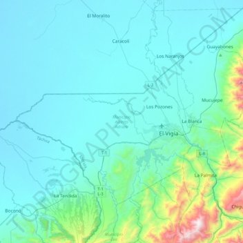
Name: Municipio Alberto Adriani topographic map, elevation, terrain.
Location: Municipio Alberto Adriani, Merida State, Venezuela (8.49344 -71.90936 8.76670 -71.51108)
Average elevation: 201 m
Minimum elevation: 13 m
Maximum elevation: 1,561 m
Make a donation
Gear up for your next adventure:
As an Amazon Associate, this site earns from qualifying purchases at no extra cost to you.
Other topographic maps
Click on a map to view its topography, its elevation and its terrain.
Mérida
Venezuela > Merida State > Municipio Libertador
This city sits on a plateau nestled in the valley of the Chama River, which runs from end to end. The town of Mérida is located at an altitude of 1,600 metres (5,200 feet). As background on the horizon rises the country's highest summit: the Pico Bolívar with an altitude of 4,981 metres (16,342 feet).
Average elevation: 2,660 m
Make a donation
Gear up for your next adventure:
As an Amazon Associate, this site earns from qualifying purchases at no extra cost to you.
Mérida
Venezuela > Merida State > Municipio Libertador
This city sits on a plateau nestled in the valley of the Chama River, which runs from end to end. The town of Mérida is located at an altitude of 1,600 metres (5,200 feet). As background on the horizon rises the country's highest summit: the Pico Bolívar with an altitude of 4,981 metres (16,342 feet).
Average elevation: 2,660 m
Páramo de Santo Domingo
Venezuela > Merida State > Municipio Cardenal Quintero
Average elevation: 3,739 m
Make a donation
Gear up for your next adventure:
As an Amazon Associate, this site earns from qualifying purchases at no extra cost to you.
Mucuchíes
Venezuela > Merida State > Municipio Rangel
Mucuchíes is a town in the Rangel Municipality of Mérida State, Venezuela. It is at an altitude of 2,983 meters and has a cool climate, with an average temperature of 11 °C. Patron saint festivities are held during the month of December, with their patron saints St. Lucia and St. Benedict the Moor. The town…
Average elevation: 3,403 m