Geolocate

Standish topographic map

Click on the map to display elevation.

About this map
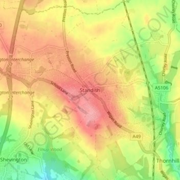
Name: Standish topographic map, elevation, terrain.

Location: Standish, Wigan, Greater Manchester, England, WN6 0HR, United Kingdom (53.56643 -2.68395 53.60643 -2.64395)

Average elevation: 85 m

Minimum elevation: 32 m

Maximum elevation: 124 m

England trails, hiking, mountain biking, running and outdoor activities

Other topographic maps

Click on a map to view its topography, its elevation and its terrain.

Haigh

United Kingdom > England > Wigan > Haigh

Average elevation: 103 m

Lilford Woods

United Kingdom > England > Wigan > Howe Bridge > Lilford

Average elevation: 33 m

Three Sisters Lake

United Kingdom > England > Wigan > Bryn

Average elevation: 50 m

Gear up for your next adventure:

⌚Altimeter Watches - Watches measuring altitude for mountain activities
🧦Hiking Socks - Breathable socks designed to prevent blisters on long walks
🚲Cycling GPS Computers - Track elevation and topographic routes on two wheels
⛺Lightweight Solo Tents - Backpacking tents designed for wild camping in the UK highlands
🌦️Portable Weather Meters - Handheld tools for monitoring weather conditions

As an Amazon Associate, this site earns from qualifying purchases at no extra cost to you.