
Perryville topographic map
Interactive map
Click on the map to display elevation.
About this map
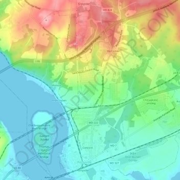
Name: Perryville topographic map, elevation, terrain.
Location: Perryville, Cecil County, Maryland, 21903, United States (39.55491 -76.08821 39.60168 -76.04161)
Average elevation: 46 m
Minimum elevation: -1 m
Maximum elevation: 129 m
Other topographic maps
Click on a map to view its topography, its elevation and its terrain.
Cecil Manor
United States > Maryland > Cecil County
Cecil Manor, Cecil County, Maryland, 21920, United States
Average elevation: 44 m
Heritage Valley
United States > Maryland > Cecil County > Elkton
Heritage Valley, Elkton, Cecil County, Maryland, 21922, United States
Average elevation: 15 m
Elkton
United States > Maryland > Cecil County
Elkton, Cecil County, Maryland, 21922, United States
Average elevation: 20 m
Westminister
United States > Maryland > Cecil County
Westminister, Cecil County, Maryland, 21901, United States
Average elevation: 99 m
New Valley
United States > Maryland > Cecil County > New Valley
New Valley, Cecil County, Maryland, 21918, United States
Average elevation: 64 m