
Thank you for supporting this site ❤️
Make a donation
Make a donation
Gear up for your next adventure:
As an Amazon Associate, this site earns from qualifying purchases at no extra cost to you.
Lires topographic map
Click on the map to display elevation.
Thank you for supporting this site ❤️
Make a donation
Make a donation
Gear up for your next adventure:
As an Amazon Associate, this site earns from qualifying purchases at no extra cost to you.
About this map
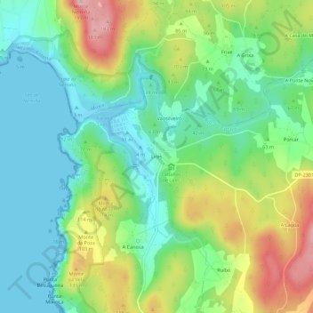
Name: Lires topographic map, elevation, terrain.
Location: Lires, Cee, Fisterra, A Coruña, Galicia, 15138, Spain (42.97818 -9.26397 43.01818 -9.22397)
Average elevation: 63 m
Minimum elevation: -1 m
Maximum elevation: 184 m
Thank you for supporting this site ❤️
Make a donation
Make a donation
Gear up for your next adventure:
As an Amazon Associate, this site earns from qualifying purchases at no extra cost to you.