
Herxheim topographic map
Interactive map
Click on the map to display elevation.
About this map
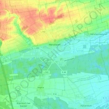
Name: Herxheim topographic map, elevation, terrain.
Average elevation: 130 m
Minimum elevation: 112 m
Maximum elevation: 162 m
Other topographic maps
Click on a map to view its topography, its elevation and its terrain.
Brunnel
Germany > Rhineland-Palatinate > Landkreis Südliche Weinstraße > Steinfeld
Brunnel, Steinfeld, Bad Bergzabern, Landkreis Südliche Weinstraße, Rhineland-Palatinate, Germany
Average elevation: 140 m
Vorderweidenthal
Germany > Rhineland-Palatinate > Landkreis Südliche Weinstraße > Vorderweidenthal
Vorderweidenthal, Bad Bergzabern, Landkreis Südliche Weinstraße, Rhineland-Palatinate, Germany
Average elevation: 298 m
Altdorf
Germany > Rhineland-Palatinate > Landkreis Südliche Weinstraße > Altdorf
Altdorf, Edenkoben, Landkreis Südliche Weinstraße, Rhineland-Palatinate, 67482, Germany
Average elevation: 148 m
Dierbach
Germany > Rhineland-Palatinate > Landkreis Südliche Weinstraße > Dierbach
Dierbach, Bad Bergzabern, Landkreis Südliche Weinstraße, Rhineland-Palatinate, Germany
Average elevation: 162 m