
Make a donation
Gear up for your next adventure:
As an Amazon Associate, this site earns from qualifying purchases at no extra cost to you.
Sitia Municipal Unit topographic map
Click on the map to display elevation.
Make a donation
Gear up for your next adventure:
As an Amazon Associate, this site earns from qualifying purchases at no extra cost to you.
About this map
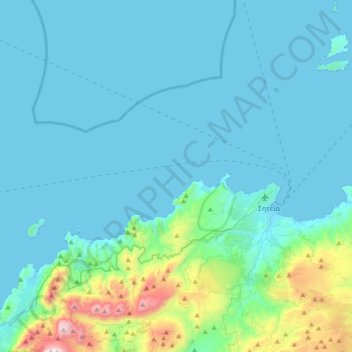
Name: Sitia Municipal Unit topographic map, elevation, terrain.
Average elevation: 163 m
Minimum elevation: -1 m
Maximum elevation: 1,369 m
Make a donation
Gear up for your next adventure:
As an Amazon Associate, this site earns from qualifying purchases at no extra cost to you.
Other topographic maps
Click on a map to view its topography, its elevation and its terrain.
Ρίζα
Greece > Region of Crete > Lasithi Regional Unit > Ierapetra Municipal Unit
Average elevation: 553 m
Sisi
Greece > Region of Crete > Lasithi Regional Unit > Vrachasi Municipal Unit
Average elevation: 58 m
Vrachasi
Greece > Region of Crete > Lasithi Regional Unit > Vrachasi Municipal Unit
Average elevation: 363 m
Ierapetra
Greece > Region of Crete > Lasithi Regional Unit > Ierapetra Municipal Unit
Average elevation: 35 m
Make a donation
Gear up for your next adventure:
As an Amazon Associate, this site earns from qualifying purchases at no extra cost to you.
Milatos
Greece > Region of Crete > Lasithi Regional Unit > Neapoli Municipal Unit
Average elevation: 125 m
Stavromenos
Greece > Region of Crete > Lasithi Regional Unit > Sitia Municipal Unit
Average elevation: 297 m
Make a donation
Gear up for your next adventure:
As an Amazon Associate, this site earns from qualifying purchases at no extra cost to you.
Tsifliki
Greece > Region of Crete > Lasithi Regional Unit > Agios Nikolaos Municipal Unit
Average elevation: 107 m
Choumeriakos
Greece > Region of Crete > Lasithi Regional Unit > Neapoli Municipal Unit
Average elevation: 322 m
Make a donation
Gear up for your next adventure:
As an Amazon Associate, this site earns from qualifying purchases at no extra cost to you.
Agios Nikolaos
Greece > Region of Crete > Lasithi Regional Unit > Agios Nikolaos Municipal Unit
Average elevation: 70 m