
Make a donation
Gear up for your next adventure:
As an Amazon Associate, this site earns from qualifying purchases at no extra cost to you.
Wimborne topographic map
Click on the map to display elevation.
Make a donation
Gear up for your next adventure:
As an Amazon Associate, this site earns from qualifying purchases at no extra cost to you.
Wimborne
Wimborne is a hamlet in southern Alberta, Canada within Kneehill County. It is located approximately 58 km (36 mi) southeast of Red Deer. It has an elevation of 975 m (3,199 ft).
Make a donation
Gear up for your next adventure:
As an Amazon Associate, this site earns from qualifying purchases at no extra cost to you.
About this map
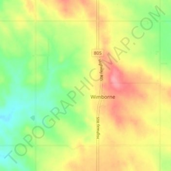
Name: Wimborne topographic map, elevation, terrain.
Location: Wimborne, Kneehill County, Alberta, Canada (51.84410 -113.61341 51.88410 -113.57341)
Average elevation: 962 m
Minimum elevation: 923 m
Maximum elevation: 1,006 m
Make a donation
Gear up for your next adventure:
As an Amazon Associate, this site earns from qualifying purchases at no extra cost to you.
Other topographic maps
Click on a map to view its topography, its elevation and its terrain.