
Thank you for supporting this site ❤️
Make a donation
Make a donation
Gear up for your next adventure:
As an Amazon Associate, this site earns from qualifying purchases at no extra cost to you.
Deotsidh topographic map
Click on the map to display elevation.
Thank you for supporting this site ❤️
Make a donation
Make a donation
Gear up for your next adventure:
As an Amazon Associate, this site earns from qualifying purchases at no extra cost to you.
About this map
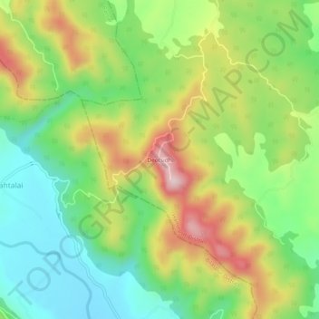
Name: Deotsidh topographic map, elevation, terrain.
Location: Deotsidh, Dhatwal, Hamirpur, Himachal Pradesh, 174030, India (31.43539 76.52298 31.47539 76.56298)
Average elevation: 721 m
Minimum elevation: 580 m
Maximum elevation: 928 m
Thank you for supporting this site ❤️
Make a donation
Make a donation
Gear up for your next adventure:
As an Amazon Associate, this site earns from qualifying purchases at no extra cost to you.