
Make a donation
Gear up for your next adventure:
As an Amazon Associate, this site earns from qualifying purchases at no extra cost to you.
Vilnius topographic map
Click on the map to display elevation.
Gear up for your next adventure:
As an Amazon Associate, this site earns from qualifying purchases at no extra cost to you.
About this map
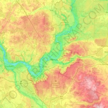
Name: Vilnius topographic map, elevation, terrain.
Location: Vilnius, Vilnius city municipality, Vilnius County, Lithuania (54.56891 25.02454 54.83232 25.48146)
Average elevation: 162 m
Minimum elevation: 74 m
Maximum elevation: 261 m
Make a donation
Gear up for your next adventure:
As an Amazon Associate, this site earns from qualifying purchases at no extra cost to you.
Other topographic maps
Click on a map to view its topography, its elevation and its terrain.
Kruopynė Hill
Lithuania > Vilnius County > Rukainių seniūnija
Kruopinė (Žybartonys) Hill is a hill near Vilnius which is the second-highest point in Lithuania. Its elevation is 293.65 metres.
Average elevation: 262 m
Make a donation
Gear up for your next adventure:
As an Amazon Associate, this site earns from qualifying purchases at no extra cost to you.
Make a donation
Gear up for your next adventure:
As an Amazon Associate, this site earns from qualifying purchases at no extra cost to you.
Aukštojas
Lithuania > Vilnius County > Medininkai Eldership > Juozapinė
Aukštojas Hill is the highest point of Lithuania. It is located in the Medininkai Highlands, Migūnai forestry, approximately 24 kilometres (15 mi) southeast of the capital city of Vilnius. Its elevation was measured in 2004 at 293.84 metres (964.0 feet) by specialists at the Institute of Geodesy at Vilnius…
Average elevation: 264 m
Make a donation
Gear up for your next adventure:
As an Amazon Associate, this site earns from qualifying purchases at no extra cost to you.
Make a donation
Gear up for your next adventure:
As an Amazon Associate, this site earns from qualifying purchases at no extra cost to you.