
Coveñas topographic map
Interactive map
Click on the map to display elevation.
About this map
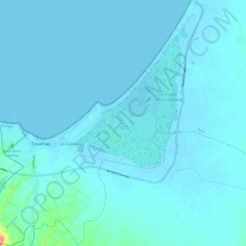
Name: Coveñas topographic map, elevation, terrain.
Location: Coveñas, Morrosquillo, Sucre, Colombia (9.35403 -75.71177 9.46868 -75.60287)
Average elevation: 7 m
Minimum elevation: -2 m
Maximum elevation: 124 m
Other topographic maps
Click on a map to view its topography, its elevation and its terrain.
San Onofre
San Onofre, Morrosquillo, Sucre, RAP Caribe, 707017, Colombia
Average elevation: 40 m