Geolocate

Bir topographic map

Click on the map to display elevation.

Bir

The paragliding launch site is in the meadow at Billing (14 km north of Bir), at an elevation of 2400 meters, while the landing site and most tourist accommodations are in the village of Chowgan (also spelled Chaugan), on the southern edge of Bir.

Wikipedia (CC-BY-SA 3.0)

About this map

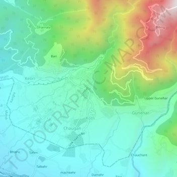
Name: Bir topographic map, elevation, terrain.

Location: Bir, Baijnath, Kangra, Himachal Pradesh, 176077, India (32.02452 76.70551 32.06452 76.74551)

Average elevation: 1,628 m

Minimum elevation: 1,284 m

Maximum elevation: 2,560 m

Gear up for your next adventure:

🧷Tenacious Repair Tape - Instant fix for torn tents, jackets, or dry bags
🖼️Topographic Map Art - Decorative 3D-effect posters of famous UK peaks and regions
🧴Tick Removal Tools - Small, essential health tool for UK woodland and moorland
📐Altimeters & Barometers - Tools for measuring altitude and air pressure
🔋Lithium AA Batteries - Long-lasting power that performs well in cold mountain weather

As an Amazon Associate, this site earns from qualifying purchases at no extra cost to you.